


SinkholeALERT: Demonstrating Disaster with Data
At Terrafirma, understanding the ground is what we do best: Our CEO Tom Backhouse was recently asked to feature in Channel 5’s documentary Sinkholes to provide an expert insight into the roots behind their cause. Inevitably then, when high profile sinkholes such as those at Fontmell Close, in St Albans or in Wednesbury, causing up to six million pounds of damage and evacuating families from their homes, we ask ourselves “can sinkholes be predicted?”.
Over the last few months and years, the experts at Terrafirma have meticulously observed, understood and recorded each sinkhole as they form. Now, armed with this information, Terrafirma is proud to present a new dataset and report feature; ‘SinkholeAlert’, allowing our team to examine the common themes behind these hidden dangers.
Let’s explore these themes:
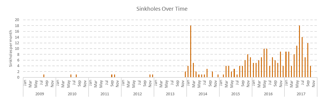
Figure 1 – Increase in reported Mining Sinkholes over time.
An Increase?
Dating from the 1st January 2014 to 9th October 2017, at least 257 Sinkholes (Figure 1) have formed around Great Britain, at a rate of around 1 each week. Examining how often sinkholes form over time, it is possible to see that (aside from a huge spike in the beginning of 2014) the number of reported sinkholes forming each month has been steadily increasing. Media coverage is now shifting to the digital platform and the ease of journalists to share information brings many more of these dangers to our attention.
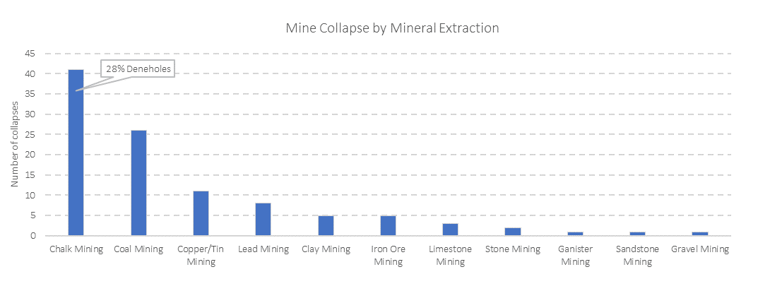
Figure 2: Types of mineral extraction and their associated sinkholes.
Historical Mining to Blame?
Since 2014, 40% of these sinkholes are the result of historical mining activity, which have left numerous cavities liable to collapse underneath agricultural land, ‘suburbia’ and commercial property. Breaking down the observed mine collapses by the mineral type, it is possible to see that mining operations historically extracting metal, chalk and coal are responsible for most sinkhole occurrences. The common culprit is chalk mining (Figure 2) and is the result of a deadly combination of factors, involving complex geological and climatic processes, historical mineral extraction methods and localised infrastructure failure. The Fontmell Close Sinkhole, in St Albans, was a particularly catastrophic example.
When it Rains, it sinks.
Rainfall is a key trigger in the formation of sinkholes across the UK, especially within bedrock rich in limestone (chalk), clay, silt, sand or evaporites (gypsum) and is something Terrafirma can demonstrate in in the data. When sinkhole occurrence frequency is plotted against rainfall, Sinkholes are more likely to occur when rainfall rates change rapidly (Figure 3 presents mine shaft sinkholes). When the ground becomes saturated with water (or becomes drained of it) changes in the stresses loading the ground cause it to move and sometimes collapse.
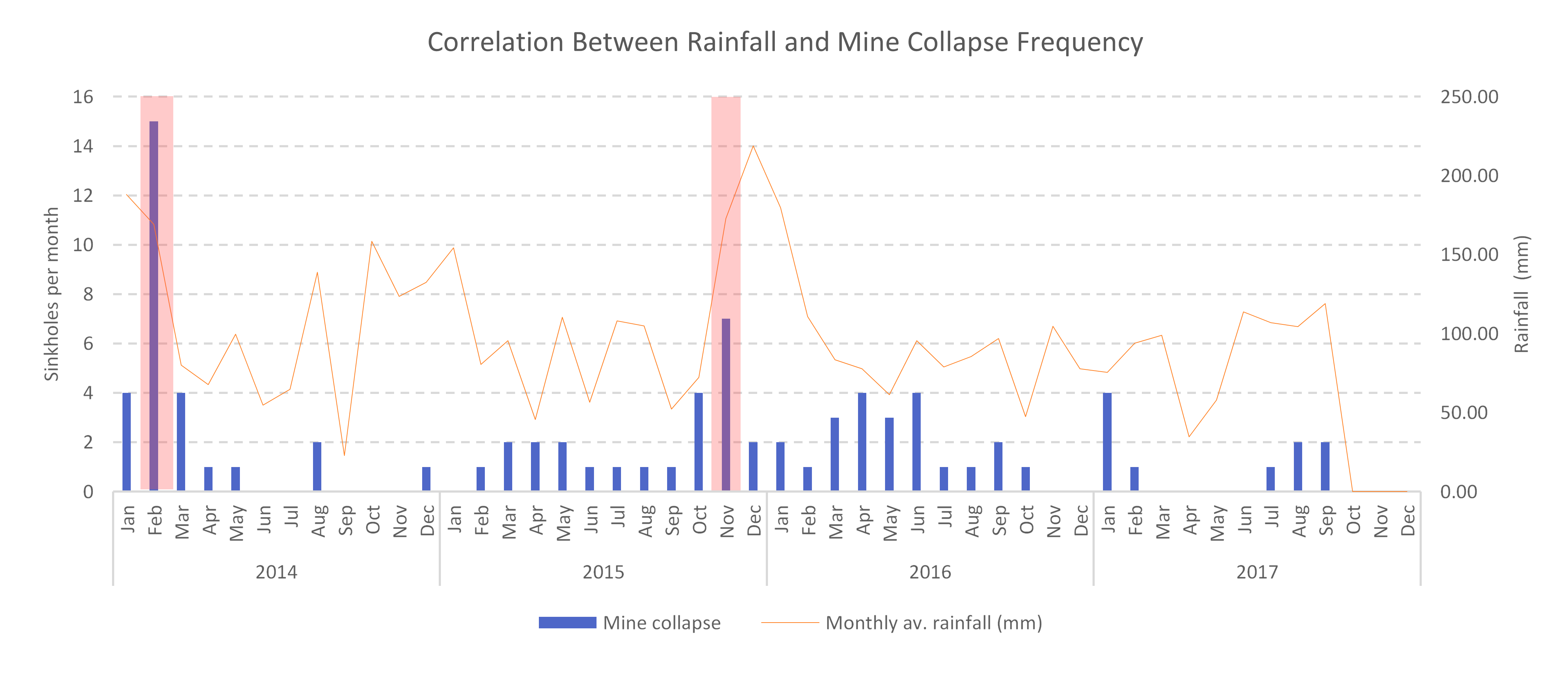
Figure 3: Plotting rainfall against mine shaft collapse and sinkhole events.
Perhaps surprisingly, sinkholes can be thought of as seasonal, with most occurring between the months of October and February. As climate change leads to wetter weather and more extreme rainfall events, it is highly likely that the number of mining sinkholes are set to increase. The potential local and community damage caused by ground collapse, subsidence and/or Sinkholes is substantial and any hidden hazard in the vicinity of property or land can cause significant disruption, structural damage, insurance premium hikes and loss of asset value.
With this in mind, now more than ever, it is essential that the risks the ground poses are expertly identified, managed and resolved, to ensure they cannot impact livelihoods negatively. Although it is not (yet) possible to accurately predict when Sinkholes will occur, with advances in data and risk modelling, it is now very possible to proactively identify where sinkholes will occur, allowing those affected to mitigate the impact of ground collapse and other hazards.
SinkholeAlert continues Terrafirma’s ambition to better educate and alert prospective homeowners to the many and varied hazards & liabilities the ground poses. TerraSearch Assess will now identify all reported sinkholes and ground collapse within 50 metres of property or site, including important details on location, date, event information and type of sinkhole.
SinkholeAlert accesses a ‘Live’ database of over 8800 sinkholes and ground collapses from across the UK, updated weekly before being located and verified by an expert geologist.
If you would like more information on Sinkholes in the UK, please visit our Hidden Hazards education portal or catch up with Sinkholes: Sucked Under on Channel 5:
Hidden Hazards: https://www.terrafirmasearch.co.uk/understand-the-ground/
Sinkholes on Channel 5: http://www.channel5.com/show/sinkholes/
Kindly shared by Terrafirma


