


New Ordnance Survey data released one year on from National Geographic Database launch
Today (28 September 2023), Ordnance Survey (OS) has released a new series of mapping data products delivering greater accuracy and details to buildings and transport features for Great Britain.
The new data is available through the OS National Geographic Database (NGD) and is set to benefit the land and property sector, utility providers, logistic and routing services and key government areas such as active travel.
The release has come one year after OS launched the NGD – its biggest step change in access to OS data in a generation. The NGD now has half a billion geographical features and 20,000 updates are submitted every day. We’ve made more than 308 million product updates to the OS NGD since its launch and there’s been over 1.4 million transactions on the OS NGD Features API.
OS location data makes a positive difference to public services and high-level decision-making every day. OS data also supports commercial customers and OS Partners, from global tech companies to transport and logistics providers. Bespoke packages can be downloaded using OS Select+Build, and our OS NGD APIs. Over 390 organisations have used OS Select+Build so far.
The new data will cover transport – the railway network, path network and information about the presence of pavements. They also cover buildings, including a new footprint geometry of all buildings with additional information on how the building is being used and is connected to other buildings. More detail below:
More detail on Transport:
-
- Coverage of Great Britain’s Path network now includes data for the whole of England, Scotland and Wales, whereas previously only urban areas were captured. This has resulted in over 10 million new path features, an increase of almost 35%. This allows further analysis on undertaking how pedestrians complete routes using road and path; and supports Active Travel policies, improvements to public health and projects to encourage walking.
- Pavement widths and their presence along roads are also included for the first time, benefitting analysis relating to those using mobility scooters, wheelchairs or pushchairs and enabling councils to support key citizen services eg maintaining pavements.
- Creation of a new generalised Rail Network for Great Britain – the first of its kind to be released by Ordnance Survey. It will allow customers to understand how well-connected areas are in relation to rail, understanding the transportation of goods, meeting their local transport needs, and also improve situational awareness for emergency services when attending emergencies on our rail network. It also shows whether the rail network is used for freight, passengers or both and whether the rails are part of the mainline.
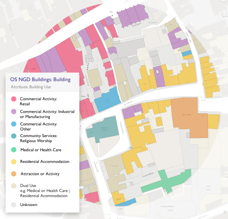
More detail on Buildings:
-
- A new building geometry represents the building footprint, making it easier than before to select and analyse individual properties.
- Providing building use (eg commercial or retail), connectivity to other buildings, identifying a primary building within a site and also providing the number of addresses which reside in a building.
- These enhancements will help emergency services with preparedness activities as well as response, providing vital data to input into risk models for insurance underwriting, and also enabling local authorities to analyse and investigate their building stock quicker than ever before.
All the new data enhancements mentioned above have been released in the OS NGD which is available to public sector customers and OS Partners through the OS Data Hub.
Customers can choose to access OS NGD data via OS Select+Build which allows users to download only the data they need, or via the OS NGD APIs.
Customers can also access technical support and information on the OS NGD in the OS NGD Documentation Platform which includes step-by-step instructions on functionality and getting the best out of our new access methods.
John Kimmance, Managing Director of OS National Mapping Services, said:
“This latest data release is yet another demonstration of the value of OS as the country’s national mapping service, providing incredibly detailed and accurate layers of geospatial data.
“This new information will enable our customers to deliver improved public and commercial services and support the promotion of healthy, sustainable and connected communities.
“We work in strong collaboration with our customers, identifying how accurate, trusted location data can help tackle the challenges they are facing, both at a national and local level.
“I am looking forward to seeing how these datasets will ultimately help people see a better place.”
The release of the new data hits a major delivery commitment under the Public Sector Geospatial Agreement (PSGA), which provides public sector organisations with trusted location data for free.
For more information about the OS Data Hub, visit here.
Kindly shared by Ordnace Survey (OS)


