


Ardwick lime works: A Manchester case study by Groundsure
Groundsure has developed a case study centring on the Ardwick lime works in Manchester, specifically looking at non-coal mining risks.
Would you be surprised if we told you that more properties are at risk from non-coal mining activity in Greater Manchester than from former coal mines?
In 2020, Manchester was home to over half a million people, a function of the boom the city has experienced since the industrial revolution. It boasts the UK’s first working canal, the first inner-city railway and became one of the largest producers of cotton.
But Manchester has lesser known but significant roots in mining and minerals. The Ardwick Limestone Mines were a complex enterprise of quarrying and subsurface extraction that lies hidden beneath today’s densely populated, bustling city.
Did you know…
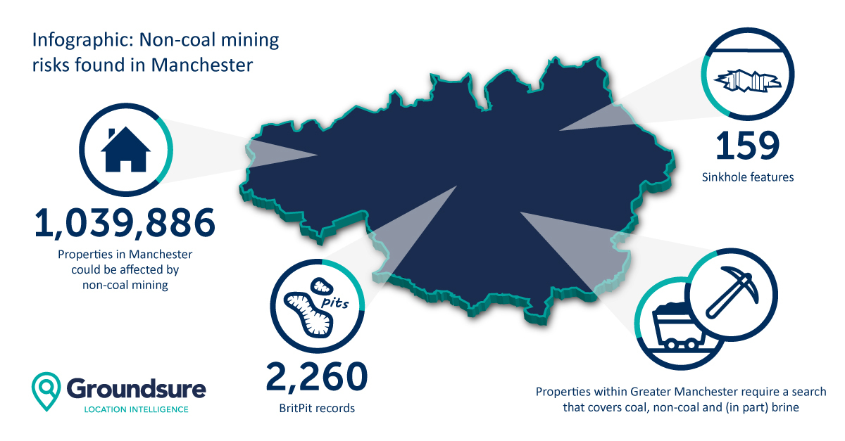
- More properties are at risk from non-coal mining activity in Greater Manchester than from former coal mines
- There are 2,260 BGS BritPit records (surface and underground mineral workings).
- 1,039,886 properties are potentially at risk from past non-coal mining activity
- 159 sinkholes have been identified from our database
- Properties within Greater Manchester require a search that covers coal, non-coal and (in part) brine
The Issue
In 2020, Manchester was home to over half a million people, a function of the boom the city has experienced since the industrial revolution. It boasts the UK’s first working canal, the first inner-city railway and became one of the largest producers of cotton.
But Manchester has lesser known but significant roots in mining and minerals. The Ardwick Limestone Mines were a complex enterprise of quarrying and subsurface extraction that lies hidden beneath today’s densely populated, bustling city.
Limestone is a highly porous, jointed rock that is more likely to dissolve with increased water being charged through the soil and especially around mine working openings and shafts where it can travel more freely. With climate change the potential for greater dissolution could expose more shafts in densely populated parts of the city as rainfall increases year on year.
Our Senior Search Writer Benjamin Oldcorn has spent lots of time digitising and interpreting the historical data relating to the mines at Ardwick and says:
“When one thinks of limestone mining in an urban area, Walsall is probably the most famous case. However, Ardwick deserves serious attention given the degree of development and population now living around and above the workings.”
The Significance
In 1848, the Ordnance Survey records the Ardwick Lime works, just east of the Medlock River. Situated over an outcrop of limestone, its aim was to exploit this large natural deposit as a source of lime mortar for the construction of multiple aqueducts.
The earlier plans record a number of large brick fields, but fail to record in detail the extent of any associated workings. Later, towards the end of the 1800s, there were signs of extraction at the surface including large clay pits and a number of shafts being sunk, as part of Ardwick’s expansion, which at its peak encompassed approximately 200,000 square metres of subterranean mines.
It was not the job of the Ordnance Survey to report on underground operations. This was down to the mine owners, who upon abandonment were legally required to produce and formally deposit a plan of the mines workings to the Mining Record Office. This plan was produced in 1899 and shows in detail the extent of the limestone removed as well as a number of shafts sunk down onto the deposit along with portals or access points driven horizontally into the mine.
Whilst records of the later workings at Ardwick are relatively complete, there is evidence of tools dating back to the Roman occupation. These are revealed by primitive tool markings, typical of this period. Also, limestone that was identified specific to the mines at Ardwick has been found at Roman sites throughout the city. It highlights that even if there is a seemingly comprehensive history of the site, there is always the risk of workings dating back before records began.
The Solution
We are able to provide detailed research into the history of a region itself in order to deliver the best insight for clients to verify the degree of risk. Our consultants look for tell-tale signs of primitive mining whilst analysing more contemporary sources to calculate things like a unique zone of influence for the 19th Century expansion of the mine. Given the potential for increased erosion of sub-surface limestone mine openings with future climate change and higher rainfall, it is important to accurately identify these in relation to the property. Equally, we can put clients’ minds at rest to ensure that transactions are able to continue smoothly.
Kindly shared by Groundsure
Main photo courtesy of Pixabay


