


Protect Property with a Professional Opinion when it comes to Mining and Ground risks by Tom Backhouse, Lead Geologist & MD, Terrafirma
The age of solely relying on data in environmental risk assessment is over, with a visible shift in the way professionals perceive risks such as contaminated land and flood.
Where historically data alone was enough to accept due diligence, now both a professional opinion and interpretative data modelling is a standard in assessing and managing these environmental hazards.
With an increase in both the visibility and potency of these risks, combined with evolving technology and common practice in the financial, insurance and legal sectors, a much more proactive and professional approach is now taken in the identification and management of both flood and contaminated land. However, despite the significant annual financial expenditure (between 4 and 15% of all insurance claims in the past 5 years were attributed to subsidence1) and the increasing visibility of the ‘Sinkhole’ phenomena, this shift in due diligence process has not been replicated in assessing the risks the ground pose.
The simplest example of this is in the risks posed by historical mining and mineral extraction. While it can be said that a significant proportion of UK properties are within 250 metres of land that might have been used for mining activity, this does not necessarily mean they are at risk of ground instability problems; simply relying on data alone is not enough to prove a risk applies to a specific property.
The same principle exists for properties where no data is available and this has been the root cause of significant issues in recent new build developments, such as at Bayfield Estate, North Tyneside2, where substantial ground collapse occurred, only shortly after construction. Simply, if no data is available, then it cannot be concluded that there is no risk present. Only by combining comprehensive and varied data sources with expert professional interpretation can a clear, accurate and reliable picture be built of the likely hazards present.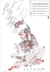
Historically, an outcome was based on whether a piece of data existed and if so, how far it is from the location in question. This is the equivalent to reporting that a property is five metres from a river and therefore at risk of flooding, only for simple professional interpretation to point out that the property was constructed at the top of a cliff and therefore not susceptible, despite the rivers proximity. This process of assessing risk for flood and contaminated land is now common in property, financial and insurance due diligence but until recently was not used in the identification of ground risks. Mining and geohazards are a specialist area of expertise and so by using limited data and vague regional knowledge, a misleading and potentially dangerous illustration of where mining risks actually are can be made.
The UK is globally unique in its 5000-year-old mining legacy. Although many appreciate that coal has been extensively mined in Northern England and Cornwall is famous for its tin mining heritage, what many do not know is that one in two UK properties are within 100 metres of a mining feature that is not coal or tin (there have been over 60 minerals mined and quarried in the UK) and that some localities within Greater London and the East of England are at significant risk of historical chalk mining. The attached map visualises the nationwide spread of the different mining risks.
To emphasise this further, greater than 60% of all mining-related sinkholes in the last two years have occurred within the South and East of England, with 12 sinkholes less than 15 miles from Canary Wharf, London3. The age-old assumption that mining solely affects ‘The North’ must be replaced by both the correct education of where risks actually exist and the proactive identification and management of hazards, where applicable.
As professionals have already accepted and adopted the practice of combining data and technical expertise in other environmental problems, a precedent will be quickly set in applying the same process to ground risk assessment. Considering the unprecedented increase in ground-related hazards in the UK, it is now essential to think carefully before purchasing a report based solely on limited data, not containing both a professional opinion or the appropriate legal and financial protection.
Kindly shared by Terrafirma


